


bois de la Herangeres

thle
User
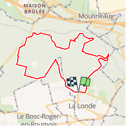

Length
17.4 km

Max alt
148 m

Uphill gradient
335 m
Km-Effort
22 km

Min alt
49 m

Downhill gradient
336 m
Boucle
Yes
Creation date :
2019-01-15 18:08:28.135
Updated on :
2019-01-15 18:08:28.135
2h43
Difficulty : Easy

FREE GPS app for hiking
 SityTrail
IGN / Geographical institutes
SityTrail Plus
The world is yours!
About
Trail Equestrian of 17.4 km to be discovered at Normandy, Seine-Maritime, La Londe. This trail is proposed by thle.
Description
Dans la foret de la londe
Positioning
Country:
France
Region :
Normandy
Department/Province :
Seine-Maritime
Municipality :
La Londe
Location:
Unknown
Start:(Dec)
Start:(UTM)
351163 ; 5463557 (31U) N.
Comments